🎉 Up to 70% Off Selected ItemsShop Sale

Long Distance Route - Great Glen Way
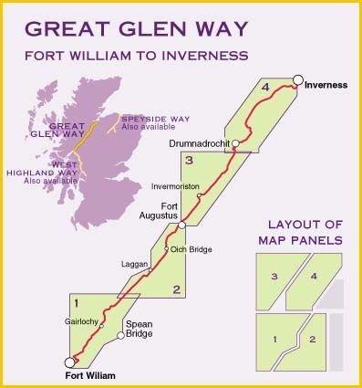
Harvey's Long Distance Route, the Great Glen Way, shows the entire route on one map. The map covers 117km (73 miles) from Fort William to Inverness via Fort Augustus along the Caledonian Canal and the north side of Loch Ness. Also shown is the Great Glen Cycle Route. Information on finding accommodation, camping, and places to eat are inculded in this useful map, and also included are directions to the start of the route.
Scale - 1:40,000.
- Durable and lightweight
- Detailed mapping (can be used with GPS)
- Also included are Ranger Service contact numbers and enlargements of towns/villages showing facilities available and tips on weather and clothing
Harvey's Long Distance Route, the Great Glen Way, shows the entire route on one map. The map covers 117km (73 miles) from Fort William to Inverness via Fort Augustus along the Caledonian Canal and the north side of Loch Ness. Also shown is the Great Glen Cycle Route. Information on finding accommodation, camping, and places to eat are inculded in this useful map, and also included are directions to the start of the route.
Scale - 1:40,000.
- Durable and lightweight
- Detailed mapping (can be used with GPS)
- Also included are Ranger Service contact numbers and enlargements of towns/villages showing facilities available and tips on weather and clothing
$7.78
Original: $22.23
-65%Long Distance Route - Great Glen Way—
$22.23
$7.78Description
Harvey's Long Distance Route, the Great Glen Way, shows the entire route on one map. The map covers 117km (73 miles) from Fort William to Inverness via Fort Augustus along the Caledonian Canal and the north side of Loch Ness. Also shown is the Great Glen Cycle Route. Information on finding accommodation, camping, and places to eat are inculded in this useful map, and also included are directions to the start of the route.
Scale - 1:40,000.
- Durable and lightweight
- Detailed mapping (can be used with GPS)
- Also included are Ranger Service contact numbers and enlargements of towns/villages showing facilities available and tips on weather and clothing